
For years I’d seen photos of a stunning rock cliff face that leaned out over a massive fjord. The sheer majesty of the formation and the presence it conveyed – even in photos – captivated me. I knew at some point I’d have to track down where the images and videos were shot and find my way there. The spot has been featured in base jumping videos, wingsuit videos and more than a few rugged adventure photo sets. Despite it’s relative popularity, the actual name and location of the spot was anything but easy to track down. In many ways it’s one of Norway’s worst kept secrets. Once you know what to look for it’s easy to find – but until then it’s not something you’ll just accidentally stumble upon.
As my Norway trip started to take shape, I knew that if at all possible a stop at what I later came to learn was commonly referred to as Preikestolen or the Preacher’s Pulpit was an absolute must. To my surprise I learned that Preikestolen was best accessed via a mid-sized Norwegian town I’d never heard of: Stavanger. The city is the 3rd largest in Norway and regularly hailed as the Nation’s Culture Capital due to its thriving music scene.
Eager to see Preikestolen, I based my Norway visit around a stop in Stavanger even though it meant I had to cut out my planned exploration of the Northern half of Norway and a return to the Arctic Circle.

My morning began with a hint of uncertainty. Taking advantage of the private room and a quiet night in, I’d done my laundry in the sink/shower the night before. As experienced travelers no doubt are well aware that means clothing hanging from every possible surface and a room that looks like it has been struck by a tornado. According to the website, I’d be doing a Tide.no tour. For 200 NOK the self guided tour included round trip ferry transport from Stavanger to Tau, then Bus transport from Tau to the Hotel/basecamp which is located about 3.8KM and 1,000 feet in altitude from Preikestolen. The catch? I wasn’t entirely sure which side of the old port in Stavanger the ferry left from. Even after doing a bit of research online I was still somewhat uncertain. Though, luckily, I remembered wandering past what looked like a Tide ferry terminal the day before. Using that as a base, I caught the bus and struck out for what I hoped was the 9:30 ferry.
Sometimes its better to be lucky than smart. As it turned out, a combination of the two worked to my favor. I arrived shortly after 8AM, slightly out of breath, found a ticket window and got directions. The attendant informed me that tickets for “Tour 4” could be purchased on the boat and that it would be departing at 9. After a moments hesitation and confusion over the 9AM departure time (all of their paperwork said 9:30) I forded across a nearby street, wading through the heavy flow of traffic and found a small SPAR supermarket selling a relatively cheap hotdog.
Eventually I found myself on a large car ferry. The ferry itself was nice and offered a great view from the top deck as well as fairly comfortable seating inside for those eager to escape the sun or light ocean breeze. As it turns out, there are actually two ferries that make the Stavanger – Tau trip. One at 8:45 and the other at 9:30. The 9:30 aligns directly with the Tau -> Basecamp Bus, but both are equally convenient.
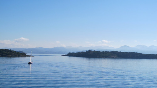
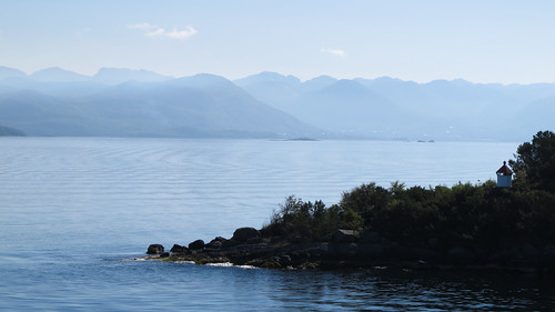
The trip to Tau was gorgeous. The weather was perfect. Slightly cool, crystal clear blue skies, with a slight breeze to keep you feeling refreshed and invigorated, I couldn’t help but relish every moment as our ferry (turned budget cruise ship) wound its way through several small channels cut between beautiful rock islands. Many of which had small lighthouses or picturesque villages sandwiched into tiny coves. From time to time I’d spot a small sailboat making its way across the fjord’s flat waters – each looking as though it was an old oil painting come to life, all set to the backdrop of large mountains turned a light blue by distance and the ocean’s haze.
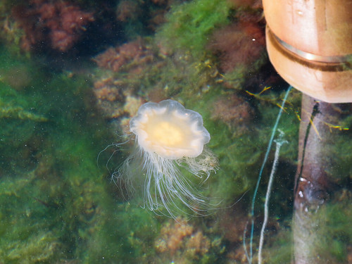

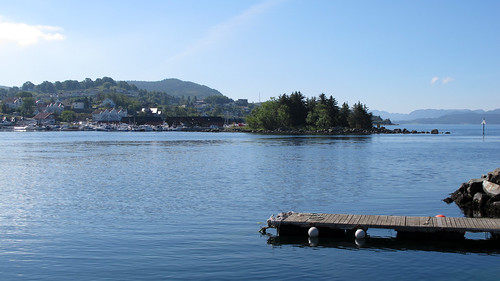
Tau Harbor was simple. A long cement quay for the ferry to land at, an old industrial looking structure along one side of the harbor, and a secondary sailing harbor backed by several picturesque homes hidden across the harbor behind a second, smaller breakwater. It was anything but exciting but a great place to relax for 30 minutes. I took the opportunity to explore the water’s edge. The water was a rich green but also crystal clear and full of fish, seaweed and a number of Jellyfish. In truth, just about every harbor in Norway I visited was full of Jellyfish. Some were small, most were pancake sized and others the size of a soccer ball. Though no doubt a pain for locals, the Jellyfish added an exciting curiosity and other-worldly beauty to the overall experience. Note the incredible clarity of the water in the image above. I snapped it from the small dock pictured in the previous image, right before being driven off by two full sized Swans and a mid-sized gray Swanling.
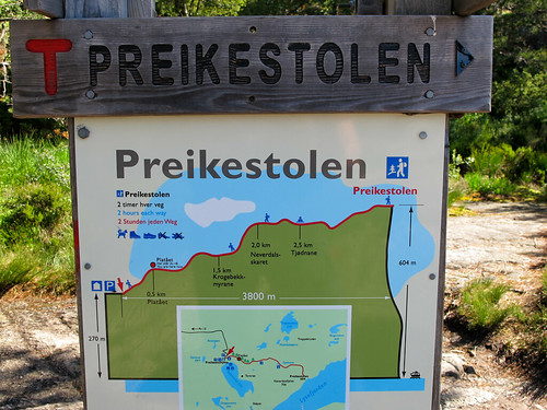
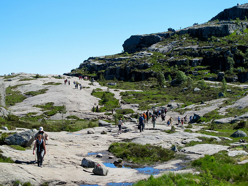
From Tau the Bus drops you off at the basecamp (not sure of its actual name). It sits overlooking a beautiful lake and is home to a large parking lot, hotel, cafe, bathrooms, a small treat and tourist knickknack store and of course the start of the Preikestolen Trail. From start to Preikestolen the hike covers 3,800 Meters (just under 12,500 feet) and is about 3.8 KM each way. From the parking lot to the top of Preikestolen there’s a 1,090 foot altitude difference which the map above showcases fairly accurately.
The path is well maintained but challenging. In addition to steep inclines it consists of a mixture of lightly graveled paths, wooden boardwalks, natural terrain and large piled rock fields. While the majority of the path is doable without the use of your hands there are more than a few spots where you’ll find yourself using hands to stabilize yourself as you scramble from small boulder to small boulder. Despite the path’s difficult nature there was a wide cross section of people hiking the trail. Some old, some young. Some thin and fit, others not so much. The biggest deciding factor seemed to be pace and water. When hiking the trail, make sure you take more than enough water with you and move at a pace you’re comfortable with. Don’t rush. I had a liter as well as a 20 oz soda and was thoroughly parched by the time I finished the hike. Having enough water, and taking your time on the treacherous footing should allow just about anyone to make the hike assuming – of course – that they’re up for a7 (almost 8) KM hike over rough terrain.
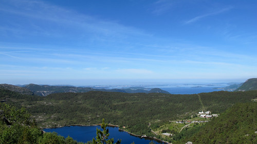
The path is what I’d call a sprinter’s path. It sprints up large inclines quickly before leaving hikers to meander along relatively flat spaces across beautiful boggy meadows or polished granite hilltops with incredible views of lakes or fjords stretching out towards the horizon.
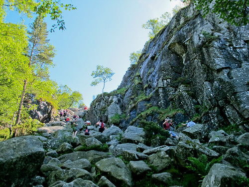
As you break through the halfway point you’re forced to make one final great push. The hill pictured above is slightly steeper (if only slightly) than some of the other areas. You can see the moss covered, fern decorated rocks which make up the path and perhaps get a feel for what to expect during the “sprint” phases of the hike. Mind the ankles – it can be a bit dangerous.

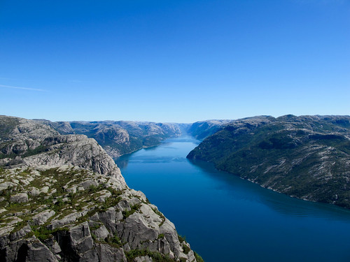
The reward, however, is well worth the effort. After completing the last difficult scramble, you find yourself upon the spine of one of the hills. You’ll also get to enjoy your first view of the Lysefjoren. It’s spectacular. There’s really no other way to describe it.
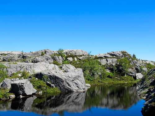
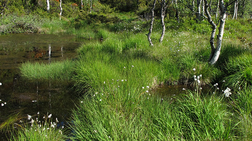
Well, when I said final push…I didn’t truly mean final, final. Once on the spine of the mountain, you wind your way up a far more gradual incline. With only one or two relatively small rock scrambles, you wind through a mixture of scenery like that in the photo above and lush green forest before getting dumped out next to three small lakes in an area largely devoid of trees. The lakes double as swimming holes for those brave enough to risk the frigid Norwegian water and were home to massive schools of tadpoles.
With the lakes to my back, I began to make my way towards what I hoped was getting close to Preikestolen. Shortly after the lakes I was greeted by a wooden sign with two options. One was the cliff top path, the other was the hill top path. I opted for the cliff top path, which looked like it would wrap around the remaining crest of the mountain, instead of cutting up and over it. A decision I’d suggest anyone making the hike consider. The hill top path makes for a far better return trip as part of a giant loop.
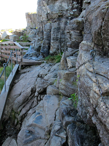
Though most of the remaining path was fairly easy, there were a few challenging spots. There’s nothing that gets the heart pumping quite like a chain link hand rail, uneven rocks and a several hundred foot drop to the left.
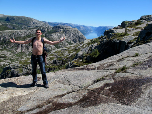
The weather was incredible. Hardly a cloud in the sky, relatively survivable humidity and a gentle breeze – which while absolutely perfect was more than a little toasty. By the time I reached the 2/3 point I’d surrendered my shirt and was relishing every step. There’s something spectacular about a good hike in an amazing setting surrounded by crystal clean air with blue skies in every direction. Throw in a few spectacular cliffs and a massive fjord in the background and you’ve got paradise. As I continued along the cliff top the path cut inland briefly, turned a few corners…
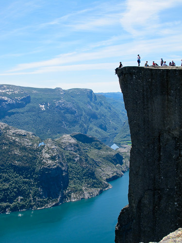
…and then rounded a ledge and stopped me in my tracks. The sheer cliff face fell away to my left, some 1,800 feet down to the Fjord and there ahead of me I could just make out the small dots of fellow hikers exploring and enjoying Preikestolen.

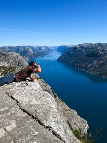
Even though my final destination was finally within eyesight and reach I still paused briefly to rest and take in the cliff I was standing immediately next to. I knew that Preikestolen itself would be incredible, but couldn’t help but be awed by the sheer drop off I was standing next to. So, I did what anyone with a reasonable fear of heights would do. I sat down, swung my legs out into the breeze, tried not to whimper like a little girl, and took a photo…then paused and enjoyed the moment and view of the fjord below.

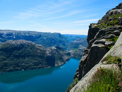
Still feeling a bit light headed from my glance over the cliff I collected myself, dusted my pants off and started towards Preikestolen. I didn’t have to walk far before being greeted by the cliff in its full majesty. Keep in mind that what you’re looking at in the image seems tall, but loses some of its power and scale. From clifftop to water is about 1,900 feet. If you figure 10 feet per story, that’s the equivalent of 190 story building. Not half bad ehh?
The fjord that sits at the base of Preikestolen is the Lysefjorden and is accessible from Stavanger via a variety of fjord cruises though I have to admit, after seeing it from above, I doubt that I’d be satisfied taking a ferry based tour.
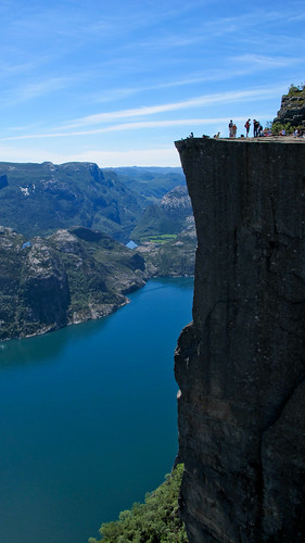
As I settled in on top of the 82×82 foot flat top of Preikestolen to enjoy my lunch I couldn’t help but pinch myself. This is why I’d come to Norway. This is what I’d dreamed of – and the best part? It was living up to every ounce of my expectations.
Preikestolen is effectively a giant square which protrudes from the surrounding cliff. The cool thing about this is that it also has one corner which is perfectly laid out to serve as a seat. One very lofty, heart pounding, slightly windy seat (pictured above). So, not to miss out on a once in a lifetime experience I gathered up my courage, overcame my fears and carefully scooted my way out to the point, then dropped a leg over either side and sat straddling the point. Luckily, I’d befriended a Korean couple on the ferry and run into them again at the Pulpit, which left me feeling comfortable enough to trust the husband with my camera. No small feat (or request on my part) since it required he backtrack a few hundred feet to another smaller point to take the photo.
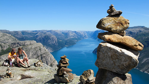
After spending an hour or so at the Pulpit I started my trip home. For the return trip, I decided to take the hill top path knowing it would take me up onto the remaining portion of the mountain, which overlooks Preikestolen. The 100 or so foot climb up above the Pulpit was well worth it as there was a series of stone cairns which decorated the top of the 2nd cliff.
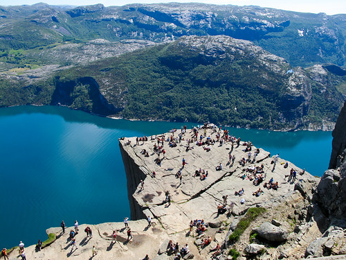
As you can see in the image above, the Pulpit’s surface area is of a decent size, but not overly large. It was also somewhat busy, but not bad when considering how incredible the weather was and that it’s effectively a world famous landmark. Still, I can only imagine how stunning it would be to stand out on it alone under a full moon at night.
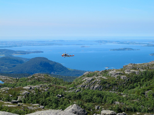
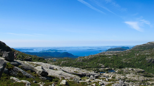
The hike back down over the top of the hill offered a spectacular view of the Fjord/bay back towards Tao and Stavanger. It also brought with it a bit of excitement. As I crested the final hill and prepared to wind back down towards the lakes I was greeted by the sight pictured above – a rescue helicopter circling the lakes, and preparing to pick someone up. A small crowd had gathered around what I can only imagine was a hiker who had slipped and broken a bone, or perhaps feinted from the heat. Either way, the helicopter settled in next to one of the lakes in hover mode, dropped a cable, and picked up the injured individual before winding them up, and then heading back towards town.
Beyond a gently rolled ankle and feeling terribly parched the rest of my hike back down to the base camp was every bit as beautiful and delightful as the trip up had been.
The hike as a whole was spectacular and a must do for anyone visiting Norway. It was truly incredible. If you’re thinking about doing it and have any questions (or comments) or have done it yourself please leave a comment! I’d love to keep the memory alive with continued discussion!